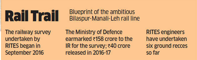
 LEH: At Upshi, 50 km south of Leh, a tiny hillock poses a big challenge to a team of railway survey men. A 16-member squad, comprising experienced railway engineers, geologists, bridge specialists and avalanche experts, tosses various options to negotiate the roadblock —from engineering a deep vertical cut to pushing the track towards the existing motor road. A senior geologist in the team is blunt: there’s no way we can have a tunnel below this heap of withered granite. There’s one more problem, points out another expert. The hillock is too short for a tunnel. So, what’s the way out? After some discord, a consensus is arrived at: let the project consultant RITES, whose survey experts did six recces of the terrain in the past, come up with two alternative solutions and freeze the matter, for good.
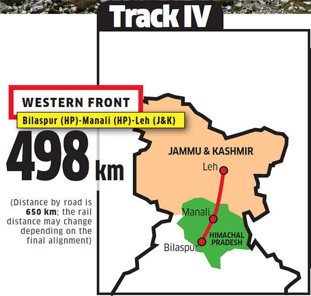
If the Government of India has its way, a railway line up to Leh — a district in Ladakh sandwiched between Pakistan occupied Kashmir in the west and China in the north and east — will be a reality in the next few years. The survey for a 498-km-long strategic railway line from Bilaspur (Himachal Pradesh) to Manali (HP) to Leh ( J&K) began in September last year. The Ministry of Defence has earmarked Rs 158 crore to the Indian Railways for the survey, with Rs 40 crore released in 2016-17. Depending on the gradients and the alignment, the route length could go up to 650 km, almost the same as the distance by road. But the big picture is this: strategically important Leh — just 250 km from the China border — will finally be connected to Delhi by an all-weather, 1,100-km-long rail route. Though defence requirements are the basic rationale for conceiving a railway line passing through a difficult terrain and high passes — 17,480-ft-high Taglang La is one of the four passes on the way — the people living in Mandi, Manali, Tandi, Keylong, Koksar, Darcha, Upshi, Karu, among other towns and villages, will find rail connectivity closer to their homes.
The cost? The survey men are tight-lipped; a tentative cost will be known by the end of next year when the second phase of the three-phase survey is completed. “Don’t be surprised if the project cost is Rs 1 lakh crore,” exclaims one of the survey men, with a disclaimer that he does not have all the requisite statistics — route length, total size of the tunnels and bridges and the like to do a back-of-the-envelope calculation.
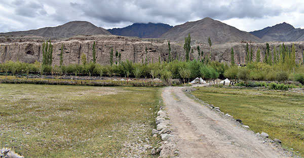
Last week ET Magazine joined this team of survey men for a stretch of 70 km from Leh to Lato, both in the Ladakh region of Jammu and Kashmir.
The entire survey is expected to take at least two more years. When it’s time for the government to take a call on its implementation, the recent tensions with China and the eventuality of future skirmishes may well determine whether it’s executed or not. After all, the Bilaspur-Manali-Leh line will go Last week ET Magazine joined this team of up to 250 km from the India-China border. It will also be the most challenging project the Railways has ever embarked upon since it involves constructions in huge mountains and avalanche-prone sections.
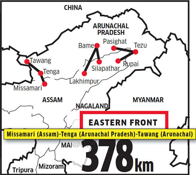
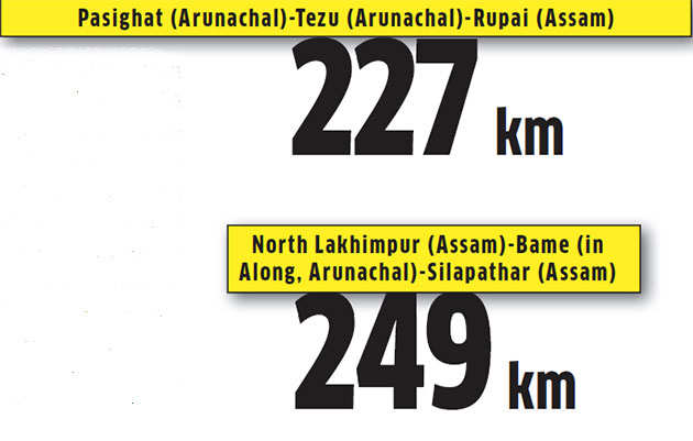
And it’s not the only line that’s planned near this critical India-China boundary. Final location surveys are also being conducted on the eastern front for three other stretches — a 378-km Missamari (Assam)-Tenga (Arunachal Pradesh)-Tawang (Arunachal) track, a 227-km-long track from Pasighat (Arunachal) to Tezu (Arunachal) to Rupai (Assam) and a 249-km route from North Lakhimpur (Assam) to Bame (in Along, Arunachal) to Silapathar (Assam). This information was in a written reply by MoS for Railways Rajen Gohain to Parliament in November last year. He added that Rs 345 crore was earmarked for surveys for the four lines, with the ministry of defence releasing Rs 87.18 crore for 2016-17.
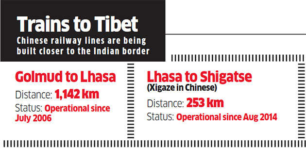
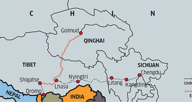
These blueprints are on the drawing board at a time when China is aggressively pushing its railway network deep into Tibet; the Indian government was jolted in 2006 when the 1,142-km-long Qinghai-Tibet Railway (QTR) became operational, bringing the railway track up to Lhasa, some 1,500 km from India. The Lhasa-Shigatse railway line was subsequently constructed, and will soon be extended to Dromo near Sikkim and Nyingtri (Nyingchi in Chinese) in north Arunachal Pradesh, the Indian state often claimed by China as its own. In fact, Dromo is close to Doklam, where India and China have just managed to end a 73-day-long standoff triggered by the intrusion of Chinese soldiers into Bhutanese territory for constructing a road project (Bhutan is a protected state of India). Despite mounting pressure from China, India did manage to hold its ground till both the countries agreed that its troops would step back by 150 m on each side.
On Thursday, China’s Foreign Minister Wang Yi at a press conference in Beijing said that while the Doklam standoff with India had “not derailed” ties, they were “damaged and affected” during those 73 days. This message came a day after Indian Army chief General Bipin Rawat reckoned that the crisis still lingers. While addressing a gathering at a seminar organised by Centre for Land Warfare Studies in New Delhi on Wednesday, the general cited how China “flexes its muscles” to take over “territory in a very gradual manner”.
On the same day, two of India’s former foreign secretaries — Shivshankar Menon and Shyam Saran — had an hour-long conversation at a book launch. Both diplomats spent some quality time to address one question: Why is China in a tearing hurry to exert its military influence in the region? They suspect it to be the fallout of China’s perception that the US under Donald Trump is on the decline, thereby giving a window of opportunity for China to gain more power. Clearly, there’s little room for India to slack off and if China is making tracks into Tibet, and towards the border, India too should be getting its act together to create similar infrastructure in the region. It won’t be easy, though.

Toughest Track
Railway officers point out that if the track to Leh gets the green signal, it will be more ambitious and grandiose than the engineering marvel that is the Udhampur-Srinagar-Baramulla rail link, with 11.2-km-long Pir Panjal railway tunnel. Only a part of that project is operational now. “The Bilaspur-Leh line will pass through four high passes, the most challenging being Taglang La (17,480 ft). The temperature variation from minus 30 degree Celsius to plus 30 degree Celsius is a big challenge. Then, there are avalanche-prone areas on the way. The proposed line falls in Seismic Zones 4 and 5.
In fact, 11% of our proposed track falls in Zone 5 (the most vulnerable to earthquakes)” says Desh Ratan Gupta, the chief engineer in-charge of construction and survey for Northern Railways. “Also, the sub-zero conditions of this magnitude do not exist in the Udhampur-Baramulla project.”
Sunil Bharadwaj from the Snow and Avalanche Study Establishment (SASE) pinpoints the challenges. “Between Kothi and Sissu (both in Himachal Pradesh), the line will pass through some of the most avalanche-prone pockets. That 70-km stretch will be a big challenge,” he says. SASE is a laboratory under the Defence Research and Development Organisation (DRDO) that forecasts avalanches, apart from undertaking their mitigation measures —both temporary (like artificial triggering) and permanent (like constructing snow galleries).

For New Delhi, junking the Bilaspur-Manali-Leh project because of the rough terrain may not be an option. From 1947, the Railways has been shying away from constructing new hill rail tracks — the toy trains of Darjeeling, Shimla and Ooty were built in the British era. The only headway made in the recent past has been the construction of rail tracks to connect seven capital cities of the northeastern states (barring Sikkim) and then the Udhampur-Baramulla rail line in Kashmir; both are incomplete.
In Leh, people are not perturbed by the recent military standoff between India and China in Doklam near Sikkim and in Pangongin Ladakh.
Sonam Angchuk, 61, a personal assistant to Shey monastery’s chief monk, is hopeful that the rail line to Ladakh will become a reality. “Can you imagine that a dozen bananas cost Rs 100 in Leh? It’s all because of transportation costs. Many commodities are bought either from Srinagar or Himachal Pradesh. The rail line will be a game-changer,” he says. Skal Zang Dolma, a former school teacher, spells out the downside. “If the railways come here, prices of goods will come down, but we don’t want Leh to turn into a dirty, low-budget tourist spot,” says Dolma, a resident of Stok, a village where Leh’s royal family resides.
ET Magazine joins a team of survey men for a 70 km stretch from Leh to Lato in the Ladakh region of J&K
For the 16-member survey team comprising railway engineers, geologists, avalanche specialists and a plainclothes colonel, the first stop in the morning is a barren piece of land by the side of the Indus river. The team is well aware of the site as most team members had visited the location in the past.
It’s one of the two proposed sites for the Leh railway station where trains from the rest of India will terminate. A couple of geologists immediately give a green signal; the colonel seems satisfied with the location, but there’s a little confusion: is the Indus river bed, which saw a massive flood in 2010, too close to the site? The team members with geological maps and handheld GPS devices take measurements before proceeding to the next destination: a large area below a hillock. A representative from the Geological Survey of India argues why he prefers the location to be on the other side of the river; but then there will be issues regarding acquisition of defence land, which may delay the project.
At many locations, there’s no dispute, thereby fast-tracking the survey. It is called a ground-proving survey as it tallies the maps with actual locations. It’s part of the final location survey, which may continue till 2019. The consultants from RITES, the rail PSU, have visited the area at least six times, and they are aware of each hillock, monastery, habitation and the like. Then there are sites where defence requirements are of utmost importance.
The survey men also try to figure out probable names for the stations, keeping in mind the local cultural ethos and heritage. One suggestion, for instance, was to name a station Hemis, after the famous monastery nearby, instead of a village called Karu.
The survey slows down after lunch at a roadside dhaba at Upshi, about 50 km south of Leh; it is faster till then because it is a repeat survey. Between Upshi and Lato, the men debate at every junction — should there be a longer tunnel; what if a deep vertical open cut is engineered in a hill for the track?
When a geologist raises objections about a location, citing poor quality rocks, it’s time for some humour, too. “Fine, fine. Should we change the alignment altogether for one hillock? Hey, let’s find a mitigation mechanism,” quips the supervising engineer.
The next morning, the survey continues, further south of Lato....
Ponying Up
Ravi Shankar Kandari, a civil engineer with RITES, has been surveying railway tracks in difficult areas for the last 20 years. He has many a story to tell — how to manage STD calls in army camps in South Kashmir and how best to woo villagers with ponies in the Reasi area of the Jammu region.
Kandari surveyed a major part of the Udhampur-Baramulla project, with a posting first in the Kashmir Valley (2001-03) and then in Jammu region till 2005. “Ponies are so well trained that even if you lose the GPS device in the hills, the animal will take you back through the same route,” he says. “Ponies are GPS machines.”
There were times when Kandari and other survey men used to stay with villagers at night by paying a nominal fee for home stays. “We used to pay Rs 250 for a pony per day. Now if you hire a pony for a day, it will cost no less than Rs 1,000,” he adds.
Once the Bilaspur-Manali-Leh survey enters Phase II in the next two months or so, and when more detailing will be required, Kandari and a few other survey men are expected to take help from villagers to understand the terrain better. “My pony rides will begin soon,” he quips.
No comments:
Post a Comment